

The Benefits of Cloud Point Surveys in Construction Projects
Laser scanning, both mobile and terrestrial as well as drone surveys are transforming the construction industry by offering unprecedented accuracy, efficiency, and insight throughout project lifecycles. From planning and execution to monitoring and reporting, this cutting-edge technology enables construction teams to minimise errors, reduce costs, and streamline workflows. New to point cloud surveying? Read our full guide to how it works.
Achieving Unmatched Precision in Construction Planning
Enhanced data accuracy is the cornerstone of effective project planning and execution in construction. Point cloud surveys and advanced laser scanning technology enable the collection of highly detailed, reliable data that forms the backbone of efficient and successful projects.
By capturing precise as-built documentation, point cloud data seamlessly integrates with Building Information Modeling (BIM), facilitating the creation of accurate 3D models and detailed 2D drawings. This integration empowers project teams to:
- Compare As-Built vs. Design Models in Real Time: Instantly identify discrepancies, enabling early detection of potential issues and reducing costly rework.
- Streamline Planning Processes: High-resolution data provides a clear understanding of site conditions, ensuring efficient workflows and optimised project timelines.
- Enhance Communication and Collaboration: Shared, accurate data fosters better collaboration among stakeholders, improving visualisation and decision-making at every project phase.
Maximising Efficiency with Point Cloud Technology
Point cloud surveys and laser scanning for the construction industry are indispensable tools for project efficiency. These technologies revolutionise the planning and execution process by:
- Accelerating Data Collection: High-speed laser scanning captures vast amounts of precise data in a fraction of the time required by traditional methods, allowing projects to progress faster.
- Reducing Rework: Early identification of design discrepancies through accurate 3D modelling minimises costly revisions and delays.
- Optimising Resource Allocation: Detailed data ensures that labour, materials, and equipment are utilised more effectively, reducing waste and lowering overall project costs.
- Supporting Complex Structures: For intricate or large-scale projects, point cloud data provides the clarity and detail required to manage challenges with confidence.
- Enhancing On-Site Safety: Comprehensive site documentation allows for better planning of safe workflows and the identification of potential hazards before they arise.
Technologies That Incorporate Point Cloud Data

Point cloud data is captured using a variety of advanced technologies, each offering unique advantages depending on the project requirements. Two common technologies that produce point cloud data and are frequently used in construction and surveying projects include LiDAR and aerial mapping.
1. LiDAR (Light Detection and Ranging)
How it works: LiDAR technology uses laser pulses to measure distances and generate highly accurate 3D data points. When used in surveying, LiDAR can capture precise details of both natural terrain and man-made structures.
Point Cloud Generation: The laser scans the environment, and the return signals are used to create a detailed point cloud representing the scanned objects or landscape.
Applications: LiDAR is widely used for topographic surveys, creating detailed 3D models, and for applications such as monitoring structural integrity, vegetation analysis, and construction planning.
Advantages: It provides extremely accurate data, even in challenging conditions such as dense vegetation or complex environments.
2. Aerial Mapping (Drones and UAVs)
How it works: Aerial surveys and mapping technology, particularly drones (UAVs – Unmanned Aerial Vehicles), equipped with high-resolution cameras and LiDAR sensors, can capture detailed images and data of large areas from the air.
Point Cloud Generation: Aerial mapping creates point clouds by using photogrammetry (from high-resolution images) or by integrating LiDAR data from drone-mounted sensors.
Applications: This method is used for large-scale land surveys, construction site monitoring, and terrain mapping.
Advantages: Aerial mapping allows for quick data collection over vast areas, reducing survey time and increasing efficiency. It’s especially useful for projects requiring comprehensive coverage, such as infrastructure projects or environmental studies.
Read our article on the latest developments in laser scanning for more information.
Point Cloud Surveys & Early Issue Detection
Early detection of issues during construction projects is crucial for maintaining project efficiency and minimising costly reworks.
Leveraging cloud point technology for surveying, specifically through laser scanning 3D modelling, offers significant benefits in this aspect. By integrating 3D laser scanning into design and planning processes, construction teams can proactively identify discrepancies between design models and as-built conditions. This early detection allows for prompt adjustments, reducing the likelihood of errors and avoiding costly rework scenarios. When surveying in Kuwait, we surveyed a complex roof structure on a building that was 12-storeys and covered a total site area of 40,000 sq m. The roof structure was very complex and it was important to verify that all the upstands were present and were at the correct height. Our survey identified a number of discrepancies allowing for prompt remediation work.
Furthermore, stakeholder collaboration during the pre-construction phase is enhanced through the utilisation of 3D laser scanning. The detailed data captured through laser scanning facilitates clear communication and visualisation, enabling stakeholders to actively participate in the project planning and decision-making process. By involving stakeholders early on, potential issues can be identified and addressed collaboratively, leading to smoother project execution and successful outcomes.
Revit BIM Modeling
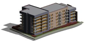
Virtual modelling capabilities enhance project visualisation and planning through immersive digital replicas of construction sites. When leveraging laser scanning 3D modelling, we enhance design and planning processes. Here’s how:
1. Accurate As-Built Documentation: By utilising point cloud surveys, we ensure precise representation of existing conditions, aiding in the creation of detailed 3D models and 2D documentation. This accuracy streamlines the design phase and facilitates real-time comparison with as-built conditions during construction, ensuring project alignment.
2. Stakeholder Collaboration: Virtual modelling enables seamless collaboration among project stakeholders. Through the visualisation of project progress, stakeholders gain a better understanding of the construction process, leading to improved decision-making and alignment.
3. Enhanced Design and Planning: The integration of point cloud data into design and planning phases allows for detailed analysis of site conditions. This integration supports better decision-making, reduces errors, and enhances overall project efficiency.
Cloud Point Surveying In Construction – Frequently Asked Questions
How Does Point Cloud Surveying Impact Project Sustainability and Environmental Considerations?
Point cloud surveying enhances sustainability by providing precise data that optimises resource use and minimises waste, supporting eco-friendly practices and long-term project viability.
What Are the Potential Challenges in Integrating Point Cloud Surveys With Existing Construction Systems?
Challenges include data compatibility, software integration, and team training. Addressing these requires careful planning, collaboration, and clear communication to ensure seamless implementation.
How Can Point Cloud Surveys Assist in Assessing Structural Integrity and Safety Measures On-Site?
By capturing detailed 3D data, these surveys help assess structural integrity and safety, allowing for early detection of risks and the enhancement of on-site safety protocols.
Elevate Your Construction Site Efficiency With Merrett Survey
ith over 40 years of experience and a proven track record of successful projects worldwide, Merrett Survey is a leader in delivering precise and efficient point cloud surveying solutions. Whether you’re planning a complex construction project or need advanced site analysis, our team is equipped with the expertise and technology to ensure the highest level of accuracy and project success.
Get in touch today to learn how our point cloud surveying services can enhance your next project. Contact us at 01392 362161, via email at info@merrettsurvey.com, or through our online contact form.

Peter Merrett - Owner & CEO
Get in Touch


