
Merrett Survey Limited provide all types of bathymetric & hydrographic survey services, as well as port and harbour surveys, ship surveys and much more. Being based in the South West of the UK, we are blessed with beautiful beaches and spectacular coastline. This has also made us all very aware of the more negative natural processes such as erosion, rising sea levels, and increasing frequency and severity of storms that affect our coasts.
Merrett Survey’s involvement with the geospatial inputs to help alleviate such processes include:
We carry out regular visits to survey beach profiles, as individual sections. Our team also applies laser scanning technology to capture the whole beach and make ‘difference map’ comparisons from year to year – or after storm events. We are experienced at both of these coastal surveying methods.
For 10 years we monitored the coastal town of Lyme Regis using a network of more than 100 permanent control stations, which were monitored using GPS / GNSS, tied in to stable structures inland.
This enabled engineers to measure ground movements and design stabilisation works for the entire town. Boreholes were also monitored regularly, measuring ground water and underground tilt or movements. Cliffs along the South West and other coasts have been regularly monitored by Merrett Survey for movement and loss of material, using laser scanning methods.
When the South West of UK was hit by a major storm that destroyed the sea defences protecting the region’s only rail link, Merrett Survey were engaged by Network Rail to scan and then monitor the slope above the railway line. This was achieved by a combination of aerial and land based laser scanning and lidar.
During the construction of DP World’s London Gateway port – the new container terminal at the mouth of the River Thames – Merrett Survey was engaged to fly aerial lidar every 6 months to monitor any changes in the inter-tidal zone. This was essential for environmental compliance during the dredging work associated with the new port build.
Whilst we specialise in land surveying, we have skills in survey work on and underneath the water as well. Our specialist team provide bathymetric surveys and hydrographic surveys as and when required for nearshore coastal and inland water way projects. To learn of more bathymetric and hydrographic projects carried out by the Merrett Survey Limited team, get in touch.
We have been involved with innovative methods of surveying the extent of biotopes (extent of marine grasses) in inter-tidal zones to monitor changes over time. This was achieved using shore based laser scanning.
Of course, all of the above includes the ‘marine environment’ but here we want to emphasise our experience with the man made connections to the marine and maritime world.
From UK to Oman, we have provided all of the survey services required for the construction of new ports or development of existing ones. This has included the detailed scanning and modelling of roll on – roll off RoRo ramps and pontoons, quay walls and dock facilities.
Plus, we have also surveyed and mapped the sub-sea environment using ‘conventional’ echo sounding, multi beam and side scan sonar to map the sea bed, sub-sea walls and piles or columns. Boat mounted laser scanning provides a good view of harbour walls and jetties that cannot otherwise be accessed.
Merrett Survey has provided high accuracy survey services for the calibration of ship board navigation equipment plus offset computations from the ship’s centreline, datum plate to GPS, GNSS antennae, roll and pitch sensors and submersible autonomous underwater vehicles (AUV) equipment.
Laser scanning can be used to rapidly survey and assess damage to vessels, plus to survey complex shapes when no existing design drawings are available.
Merrett Survey Limited has been involved in the setting out of pontoon piles and other waterfront construction – even the accurate placement of subsea anchors for a rowing course.
During beach replenishment projects, we have acted for the contractors and also for the client (UK local authorities) in surveying and measuring material volumes for accounting purposes.
Contact us if you have any questions for us in relation to our coastal survey services. Alternatively, fill out a contact form and start a conversation about your next or current project.

Merrett Survey’s work for DP World on the
London Gateway project included 6 monthly
aerial Lidar surveys of the inter-tidal zone


Scanning on board cable laying vessel
for calibration of all navigation aids, IMU
and GNSS antennae
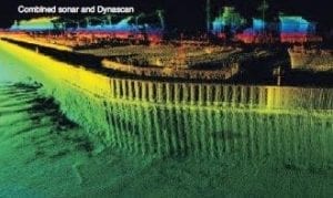
We can survey above and below water

Coastal cliff and beach erosion surveys
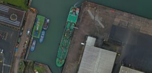
Ports and harbours surveys
