

At Merrett Survey, we provide river and floodplain mapping surveys. We use the latest technology including LiDAR airborne and LiDAR terrestrial, drone based aerial mapping as well as mapping on the ground using total stations and GPS. In the image above, an ROV (remotely operated vehicle) is being used to…

Topographical surveys, also referred to as topographic surveys, are fundamental for the successful development of any site. These surveys provide developers, architects, and engineers with a detailed, accurate understanding of the land before any construction begins. By gaining an in-depth view of the site early on, developers can reduce future…
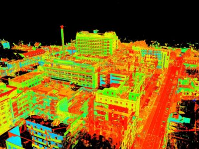
The revolution of laser scanning has transformed the way that we capture and analyse data, with the advanced technology producing point clouds that have unparalleled accuracy. This invaluable tool has meant that key industries, such as surveying, can save time and costs, enhancing productivity methods and project effectiveness overall. At…

Topographical surveys are fundamental procedures to undertake before any area of work commences upon an area of land. Within the engineering sector, it is important that all individuals show compliance and adhere to the rules and regulations, in order to accurately execute their project safely and securely. They also aid…

At Merrett Survey, topographical surveys are an imperative part of land surveying services we offer, across the UK and internationally. We create topographical surveys for our clients that cover a huge variety of project types, from survey work to upgrade Highway One from Phnom Penh to Ho Chi Minh (Cambodia…

Our technically advanced surveyors rely on LiDAR to ensure that they are able to gather important data, revolving around the shape and structure of the Earth’s surface. It is a hugely popular remote sensing method, consisting of numerous laser beams that use advanced light technology to detect the precise measurements…
