

Heritage Building Surveys: Why Specialist Expertise Matters For Conservation Projects
When a building has stood for centuries, every measurement matters. Whether you are planning a sensitive restoration, applying for listed building consent, or preparing a conservation management plan, a heritage building survey is not simply a technical exercise – it is the foundation upon which the entire project depends.
At Merrett Survey, we have decades of experience carrying out heritage building surveys across the UK and internationally. From Grade I listed churches to Victorian industrial structures, our surveyors understand that historic buildings demand an entirely different level of care, precision, and knowledge than standard commercial or residential surveys.
This article explores what sets a heritage building survey apart, why specialist expertise is essential, and how modern survey technology is transforming conservation projects.
What Is A Heritage Building Survey?
A heritage building survey is a measured survey carried out on a historic or listed structure, producing detailed drawings and data that accurately record the building as it currently stands. These surveys are used to inform restoration work, support planning and conservation applications, and provide the accurate baseline data that architects, engineers, and conservation specialists need before any intervention takes place.
Unlike a standard measured building survey, a heritage survey must capture far more than walls and floor levels. It needs to record architectural features, material variations, structural deformations, and the subtle irregularities that have accumulated over hundreds of years. A Victorian-era brick arch may have settled by several centimetres; a medieval timber frame may be far from square.
How Does A Heritage Building Survey Differ From A Standard Survey?
Accuracy requirements are higher. Conservation and restoration work requires survey accuracy in the millimetre range. When you are specifying replacement stonework, replicating decorative mouldings, or designing structural interventions within an ancient wall, there is no margin for error. A survey that is accurate to plus or minus 20mm may be acceptable for a new-build site; for a Grade II* listed building, it is not.
Architectural detail must be captured. Historic buildings contain layers of detail – cornices, reveals, string courses, mullions, door surrounds, and decorative ironwork – that a standard survey would simply ignore. Heritage surveys must capture all of this, often requiring specialist modelling skills to represent features accurately in 2D drawings or 3D models.
Deformations are data, not noise. Modern buildings are designed to be regular. Historic buildings are not. Any surveyor experienced in heritage work understands that a bowing wall or a sagging roof is part of the building’s story – and capturing it accurately is essential for both structural assessment and design.
Planning and consent requirements are more complex. Listed building consent applications and conservation area planning submissions often require specific documentation. Historic England guidance and local authority conservation officers have particular expectations about survey quality, methodology, and deliverables. Working with a surveyor who understands this regulatory landscape can make the difference between a smooth application and months of delays.
Understanding Historic England Regulations and Conservation Requirements

Any project involving a listed building or scheduled monument in England must navigate a framework of legislation and guidance that does not apply to standard construction projects. The Planning (Listed Buildings and Conservation Areas) Act 1990 is the primary legislation, but the day-to-day requirements are shaped by Historic England’s published guidance notes, local authority conservation policies, and the specific conditions attached to listed building consent.
For surveyors, the key implications are as follows:
- Survey data must be of sufficient quality to support planning applications. Consent applications for alterations to listed buildings require measured drawings that meet a recognised standard. A sketch or a basic floor plan is unlikely to satisfy a conservation officer.
- The survey must not damage the building fabric. Access methods for heritage surveys need to be agreed carefully. Scaffolding, temporary works, and the positioning of survey targets must all be considered in the context of the building’s listed status.
- The survey may need to inform a Conservation Management Plan (CMP). A CMP is a document that identifies the significance of a heritage asset and sets out policies for its management. Accurate survey data underpins the fabric recording that feeds into a CMP.
- Retrofit and sustainability work is increasingly relevant. Many heritage buildings are subject to net zero retrofit programmes. A BIM model of the existing building – created from laser scan data – allows a retrofit to be designed and tested before any works are undertaken, reducing the risk of unintended harm to historic fabric.
How We Carry Out Heritage Building Surveys
At Merrett Survey, our approach to heritage building surveys combines the latest laser scanning technology with the experience and judgement that only comes from working on a wide range of complex historic structures. Here is how a typical heritage survey project progresses:
- Project scoping and brief review – Before any fieldwork takes place, we work closely with the client – whether that is an architect, conservation officer, or project manager – to understand exactly what the survey needs to deliver. Heritage surveys are bespoke; the deliverables depend entirely on the project requirements.
- Terrestrial laser scanning – We use high-specification laser scanners, including the Leica P40 and RTC360, to capture precise point cloud data across the whole building – internally and externally. These instruments record millions of measurement points per second, producing a comprehensive three-dimensional record of the structure. The RTC360 also captures HDR imagery, providing colourised point cloud data that is invaluable for recording surface finishes and materials.
- Supplementary photogrammetry and drone survey where required – For large or complex structures, or where access is limited, we may supplement terrestrial scanning with photogrammetry or UAV surveys. Drone survey is particularly useful for capturing roof structures, high parapets, and external elevations above scaffold height.
- Point cloud processing and registration – Once back in the office, our team processes the raw scan data, registering individual scan positions into a single, coherent point cloud model of the building. This data is then cleaned and prepared for modelling.
- Production of measured drawings and BIM models – From the point cloud, our experienced Revit modellers produce the drawings and models required by the project. For heritage work, this typically includes detailed floor plans, elevations, and sections at the agreed Level of Detail (LOD). Significant architectural features, structural elements, and deformations are all modelled accurately.
- Delivery and review – Completed drawings and model data are issued to the client in the agreed formats – typically DWG, PDF, and RVT or IFC for BIM deliverables. Point cloud data is also supplied in formats such as ReCap for use by the wider project team.
Take a look at our recent article ‘How Accurate Are Point Cloud Surveys? Understanding Precision in 3D Laser Scanning’.
The Role Of BIM In Heritage Conservation
Building Information Modelling (BIM) has become an increasingly important tool in heritage conservation. A BIM model of a historic building is sometimes referred to as a HBIM (Historic Building Information Model), and it goes beyond a simple set of drawings to create a data-rich, three-dimensional digital twin of the structure.
For conservation projects, this offers a number of significant benefits. Designers can work within a fully accurate 3D model of the existing building, reducing the risk of clash and design conflicts before work begins on site. The model can be shared across the entire project team – architects, structural engineers, mechanical and electrical consultants, and conservation specialists – ensuring everyone is working from the same accurate baseline data. Where a building is subject to ongoing management and maintenance, the HBIM serves as a long-term asset record, capturing information about materials, condition, and interventions over time.
Carbon and energy performance is another growing area. With increasing pressure on building owners to reduce energy consumption – including listed buildings where permitted – a BIM model allows energy consultants to model retrofit options such as secondary glazing, insulation, and mechanical upgrades within the actual geometry of the building, assessing their impact before any consent applications are made.
Our 3D Laser Scanning and BIM services are used across a wide range of heritage projects, from individual listed properties to large, complex historic sites.
Case Study: The Pannier Market, Barnstaple
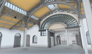
The Pannier Market in Barnstaple is a Grade II listed building that has been in continuous use since its completion in 1855. With its complex Victorian ironwork, uneven stone floors, and roof structure that has accumulated significant deformation over nearly 170 years of use, it is an excellent example of the challenges that heritage surveys present.
Merrett Survey were contracted to supply a colourised and cleaned 3D point cloud dataset compatible with Revit 2021, along with an LOD4 BIM model (equivalent to RIBA stages 3 and 4). We used both a Leica P40 and a lightweight Leica RTC360 scanner, which recorded HDR imagery throughout.
The model included external and internal walls with overall thickness modelled and identified, significant architectural features, embedded profiles for cornices and reveals, floor slabs, columns and beams, ceiling voids, windows with sills, heads, mullions, glazing bars and structural openings, stairs, and visible drainage. The project was particularly challenging due to the high degree of deformation in both the walls and the sagging roof structure – precisely the kind of complexity that demands specialist heritage surveying expertise.
The BIM model was used as part of a wider project to protect and refurbish the Pannier Market and Guild Hall, informing the repair and conservation of the historic fabric and supporting improvements to the existing facilities on site.
Why The Summer Months Are The Right Time To Commission A Heritage Survey
For heritage buildings, the summer months – particularly June through September – represent the most productive window for external survey work. Longer daylight hours, drier conditions, and better visibility all improve the quality of data capture, particularly for external laser scanning and drone surveys of roofs, towers, and upper elevations.
It is also worth bearing in mind that conservation projects tend to have long lead times. Planning applications, listed building consent, and procurement of specialist contractors all take time. If your project is targeting works in the following spring or summer, commissioning your heritage survey now means the data will be ready in time to support the design and planning process without creating a bottleneck further down the programme.
Choosing The Right Survey Partner For Your Heritage Project
Not all surveying companies are equally equipped to handle heritage work. When choosing a survey partner for a listed building or conservation project, there are several questions worth asking:
Do they have demonstrable experience with comparable historic buildings?
Case studies and project examples are the best evidence. A company that routinely surveys modern commercial buildings may not have the methodological knowledge or attention to detail that heritage work requires.
Can they deliver the specific outputs your project requires?
Heritage surveys can require anything from simple 2D CAD drawings to full Revit BIM models at LOD4 or above. Ensure your chosen surveyor has in-house modelling capability and experience with the software platforms your design team will be using.
Do they understand the regulatory context?
Surveyors who regularly work on heritage projects will be familiar with the documentation requirements of Historic England and local authority conservation teams. This knowledge helps to ensure that survey deliverables are fit for purpose from the outset, rather than requiring revision after a planning submission is queried.
What Surveying Technology Is Used In Heritage Building Work?
Laser scanning is now widely regarded as the most effective method for heritage building surveys. The technology allows surveyors to capture vast amounts of precise measurement data rapidly and without physical contact with the building fabric, which is particularly important when working in fragile or access-restricted historic environments.
Modern instruments such as the Leica P40 achieve accuracies of up to 0.6mm at typical operating ranges, making them more than capable of delivering the millimetre-level precision that heritage conservation demands. Combined with photogrammetry – which captures texture and colour information alongside geometry – laser scanning produces a rich, accurate dataset that supports both traditional drawing production and modern BIM workflows.
You can read more about how aerial surveys and drone technology complement our ground-based survey work in our article on The Advantages of Using Aerial Surveys for Land Development.
What Types Of Heritage Building Projects Do We Work On?
Our heritage surveying team works across a broad range of project types. These include listed residential buildings where owners are planning extensions, conversions, or sensitive refurbishments. We work on ecclesiastical buildings – churches, chapels, and cathedrals – where conservation programmes require accurate records of complex stone and timber structures. Industrial heritage is another specialist area: mills, engine houses, and Victorian infrastructure often combine large scale with intricate structural detail – take a look at our Redruth Brewery Heritage case study.
We also work extensively on civic and commercial heritage – market halls, theatres, municipal buildings, and historic hotels – where listed status sits alongside the demands of a working building in active use.
Further reading: Our article on Laser Scanning and BIM Surveys for the Construction Industry gives a broader overview of how laser scanning and BIM technology can be applied across a range of project types.
Commission Your Heritage Building Survey With Merrett Survey
If you are planning a conservation, restoration, or refurbishment project involving a heritage building, getting the survey right at the outset is the single most important investment you can make. Inaccurate or incomplete survey data creates problems at every stage of the project, from design through to planning consent and on-site construction.
At Merrett Survey, we combine specialist heritage expertise with the latest laser scanning and BIM technology to deliver survey data that meets the highest accuracy standards – and the expectations of conservation officers, Historic England, and your project team.
To discuss your heritage building survey requirements, contact our team today. Send us an email to info@merrettsurvey.com or call us on +44(0)1392 362161. We are happy to discuss your project, advise on survey methodology, and provide a quote tailored to your specific needs.
You can find out more about the types of heritage projects we support by visiting our Heritage sector page.

Peter Merrett - Owner & CEO
Get in Touch


