

Measured Building Surveys: A Complete Guide
If you are planning a construction, renovation or conservation project, a measured building survey is almost always the sensible first step. It gives architects, engineers, developers and contractors a precise, trusted record of a building’s dimensions and features before work begins, and that record becomes the foundation for confident design decisions and a smoother project.
In this guide we explain what a measured building survey is, what it includes, when you need one and how our laser scanning and BIM specialists deliver accurate results you can build on.
What Is A Measured Building Survey?
A measured building survey is an accurate, scaled record of a building’s dimensions, layout and features, inside, outside, or both. It captures everything from room layouts and floor levels to elevations, structural detail and architectural features, then presents them as reliable 2D drawings and 3D models.
Modern measured building surveys are produced using 3D laser scanning and BIM. A laser scanner captures millions of precise measurements to create a point cloud, which is a highly detailed digital replica of the building. Compared with traditional hand measurement, this approach offers three clear advantages:
- Accuracy: It captures intricate detail to millimetre precision, so nothing important is missed.
- Efficiency: It reduces time on site and speeds up project timelines.
- Comprehensive data: It gives you a complete 3D record for analysis, design and planning.
Our surveyors then turn that scan data into accurate 2D drawings, 3D laser scanning outputs and Revit BIM models that support design, construction and maintenance.
What A Measured Building Survey Includes
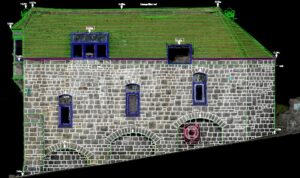
A measured building survey can be tailored to your project, and in many cases two or more of the following deliverables are combined to give a full picture of the building. The most common outputs we provide are:
- Site plans. A site plan shows how a building sits among the other features on a site, such as boundaries, neighbouring buildings, large trees, powerlines and other utilities. They are often needed by developers who want to understand a site in detail before making decisions, and they can range from a simplified topographical survey to a complex plan that includes external underground services.
- Floor plans. One of the most requested drawings, a floor plan shows the layout of rooms viewed from above and is always drawn to scale. Floor plans inform decisions on how to reconstruct or develop a building, and they can include the computation of lettable floor space. We produce both highly detailed plans and simpler versions for uses such as marketing.
- Elevations, internal and external. Elevation drawings are needed when building faces are being altered, capturing features such as doors, windows, steps and intricate architectural detail. Our internal elevations can be extremely detailed, covering everything from electrical points to elaborate stonework, and they can include reflected ceiling plans. Our building survey of Tom Johnson House in Dublin is a good example of this level of detail.
- Sections. A section drawing cuts through the building to reveal the structural relationship between different rooms and levels, including detail such as ceiling and floor thickness. Sections supplement floor plans, roof plans and elevations, giving designers a clear view of how a structure fits together, as they did on our rapid building survey of flats in Plymouth.
- Roof plans. Detailed roof plans capture high-level features such as chimneys, ridges and eaves, often in places that are difficult to access. A thorough understanding of a roof helps you avoid problems later, and where access is tricky we use drone and aerial surveys to capture a complete overview.
- Point cloud data, as-built drawings and 3D BIM models. These outputs underpin all of the above. Point cloud scanning creates a detailed 3D digital replica of the building, scaled as-built 2D drawings reflect exact existing conditions, and BIM-ready 3D models let project teams collaborate, detect clashes early and plan future works with confidence
Measured Building Survey vs Topographical Survey
These two survey types are often confused, and many projects actually need both. A topographical survey maps the site, while a measured building survey records the building itself. The table below shows the key differences at a glance.
| Aspect | Measured building survey | Topographical survey |
|---|---|---|
| What it records | A building’s structure, layout and features | The land, and features on and just below the ground |
| Typical outputs | Floor plans, elevations, sections, point cloud, 3D BIM models | Contours, levels, boundaries, site features |
| Common uses | Renovation, redevelopment, heritage, design | Development planning, engineering, site layout |
| Perspective | Inside and outside the building | The wider site and ground surface |
When You Need A Measured Building Survey
A measured building survey becomes essential whenever accurate, up-to-date information about an existing building is needed before decisions are made. The most common reasons clients come to us are:
- Commercial renovation, redevelopment or extension. Reliable floor plans, elevations and sections give designers and contractors the detail they need to plan with confidence.
- Planning and design. Accurate area referencing and documentation support a smooth planning process and help avoid design flaws.
- Heritage and conservation. Listed and historic buildings call for a careful, specialist approach and a complete record of their condition, as we explain in our guide to heritage building surveys.
- Complex or irregular buildings. Industrial facilities, large commercial developments and multi-level structures are all projects where every detail matters.
- Older buildings with undocumented changes. Extensions, alterations and repairs made over the years can present real risks during redevelopment, and a survey reveals the building’s true, current condition before you commit.
Why Accuracy Matters
On complex projects, inaccurate measurements or incomplete data cause serious setbacks, from design clashes to compliance issues and costly delays. A high-accuracy measured building survey acts as a single source of truth across all the disciplines involved, from architects and engineers to contractors and project managers. Everyone works from the same reliable information, which streamlines collaboration and improves the end result.
The benefits of getting this right are significant:
- Precise data that removes guesswork from design and construction.
- More efficient planning and scheduling from the very start of a project.
- A reduced risk of redesigns, clashes and disputes later on.
- Dependable documentation for compliance, leases and property records. A lasting digital foundation, in the form of point clouds and BIM models, for ongoing maintenance and asset management.
How a Measured Building Survey Is Carried Out
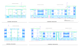
We combine the latest surveying technology with decades of practical expertise, and we choose the right method for each building. A typical project follows four straightforward stages:
- Discuss. We talk through your building, your project and the outputs you need, then advise on the best approach.
- Capture. Our surveyors scan the building on site, using laser scanning and, where access is difficult, drone and aerial survey.
- Process. We register the point cloud and produce your drawings and models to the agreed specification.
- Deliver. You receive accurate results in flexible 2D and 3D formats, ready to use across your project.
Our measured building survey services cover 3D laser scanning and Revit or BIM measured building surveys, alongside point cloud laser scanning and scan to BIM workflows. We produce floor plans, elevations, sections, site plans and roof plans, and we can also provide visualisation in VR and AR, and reality-merging of design data with scanned existing structures.
Whether we are surveying a public building, a block of flats, retail premises or a precious listed building, our aim is always the same. We advise, plan and deliver a survey that lets you get the most out of your project.
Measured Building Surveys in Practice
We have delivered measured building surveys on buildings of every type and complexity. A few examples show the range:
- Commercial premises. Our survey of an ex-Debenhams department store captured a large retail building for redevelopment.
- Heritage buildings. At Redruth Brewery we produced a detailed heritage survey of a historic structure.
- International as-built surveys. For the Kuwait Ministry of Education we delivered an accurate as-built survey overseas.
You can explore more examples on our case studies page.
Frequently Asked Questions
What is the difference between a measured building survey and a topographical survey?
A measured building survey records a building’s structure and features, such as floor plans, elevations, sections and 3D models. A topographical survey maps the land and the features on and just below the ground’s surface. Many projects use both together.
What deliverables will I receive?
This depends on your project, but it is typically a combination of point cloud data, scaled 2D as-built drawings such as floor plans, elevations and sections, and 3D BIM or Revit models. We agree on the outputs with you before we start.
How accurate is a laser-scanned measured building survey?
Laser scanning captures detail to millimetre precision, producing a highly accurate record that is suitable for design, construction and heritage work.
How long does a measured building survey take?
It varies with the size and complexity of the building and the deliverables required. Laser scanning reduces time on site significantly compared with traditional methods. Contact us with your project details and we will advise on timescales.
Do you survey listed and heritage buildings?
Yes. We regularly survey listed, historic and architecturally complex buildings, where a careful, specialist approach and complete documentation are essential.
How Merrett Survey Can Help
With nearly 40 years of experience and projects delivered in over 60 countries, we are trusted by architects, engineers, developers and contractors to capture buildings accurately and reliably. Whether you are looking for an experienced measured building surveyor to guide your project from the outset or specialist support partway through, our team is here to help, and we are always happy to discuss the best approach for your project without commitment.
Get in touch with our specialists on +44 (0)1392 362161 or email info@merrettsurvey.com to discuss your requirements and the right approach for your building.

Peter Merrett - Owner & CEO
Get in Touch


