
The word ‘engineering’ will mean different things to different disciplines and sectors. Given that most of the topographical surveys undertaken by our geospatial engineers end up being used for some form of engineering, the term is applicable to most of our projects.
However, on this page, we want to emphasise the skills we have in applying modern surveying technology, such as laser scanning and lidar, to solve problems in structures – existing or planned.
Examples of such projects include the surveying of refineries and delivering Navisworks BIM models as well as P&ID drawings. For storage tank engineers, we are able to provide highly accurate strapping tables, shell deformation analysis, surveys for tank bottom and foundation settlement, shell out-of-roundness, structural column verticality, and much more.
By providing a geometric evaluation of the tank in its current state, we can provide 3D models and layout drawings of the floor, shell, roof structure, and attached infrastructure. This data can assist with assessment of tank integrity, risk analysis, design of floating roofs – ensuring they fit – and much more.
In Kuwait, our geospatial engineers surveyed the steel roof structure of a major new Government Ministry building, so that upstands could be cut to size in order to ensure the curved roof panels (built offsite) would fit on arrival. Such work ensured clash avoidance, which saved the client a large amount of money.
In Egypt, we are tasked to monitor the levels of bench marks surrounding power station turbines in both the running mode (hot) and in shutdown (cold) to ensure the central axis remains straight.
In the UK, we used a combination of UAV photogrammetry and laser scanning to survey the inside of one of the chimneys at the famous Battersea Power station. The station is now being converted to residential use, so the engineers can design the installation of a lift that will take visitors to the top of the chimney for panoramic views over London.
In Wales, we surveyed Aberthaw Power Station. We produced a 3D model that was delivered to engineering firms, who carried out the FEED (Front End Engineering and Design) study for installation of new equipment. We can scan your plant or factory to ensure that retrofit design projects are carried out efficiently by reducing clashes and rework.
We have surveyed and monitored masonry structures, checking for movement, measurement deformation and verticality/‘out of true’ for various walls. Concrete highway bridges have been measured using our high accuracy laser scanning methods to detect ‘spalling’ and deterioration of the reinforced concrete.
Setting out work, or staking out, have been undertaken in the London Olympic stadium and in factories to high accuracies, before the installation of new equipment, for installation of solar farms, and on new build steel frame buildings.
In rivers prior to building weirs and out-takes for hydro electric schemes, we have conducted coastal & marine bathymetric surveys. Merrett Survey provided cliff monitoring using both ground based and airborne LiDAR subsequent to the collapse of the cliff in Dawlish, affecting the rail line.
As you can see, our experience is wide and varied and we like solving problems. Let us know how we can assist you on your engineering project – whatever your definition of ‘engineering’. Contact us today by filling out the form below, or by getting in touch over the phone.
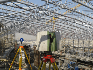
Checking of roof upstands – Kuwait
using laser scanning technology
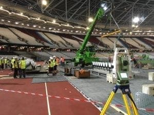
Setting out work – Olympic Stadium London
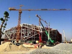
Site progress surveys
