

A Look At Our Coastal Topographical And Bathymetric Survey Services
We have had a lot of marine and coastal work lately. Is it because the UK’s overseas trade is increasing? Is it that we have managed to promote our skills in the coastal & marine sector in providing topographical and bathymetric surveys to more people? Is it that the marine transport industry is becoming more automated / digital or is that the nation’s marine infrastructure is ageing and needs upgrading?
The answer is probably ‘all of the above’. But we’re happy to have worked in the ports of Peterhead in Scotland, Pembroke in Wales, Southampton, Plymouth, Penzance, Harwich, London Gateway and Liverpool. As such, we thought we’d discuss some of our recent coastal and marine bathymetric surveys and our related services.
Our Recent Topographical & Bathymetric Survey Projects
As a premier topographical survey company based in the south west, we are no strangers to conducting survey work by the waterside. We have had several recent projects in the coastal & marine sector where our topographical and bathymetric survey services were required. Some examples of our work include:
– Putting our skills to use in the survey of port facilities for RoRo ferry structures (to be replaced or upgraded)
– Conducting our services for the upgrade of oil jetties, including survey and 3D BIM modelling of the complex pipework associated with the project.
– Surveyed historic dry docks – see more below.
– Tidal dock gate refurbishment – where we accurately survey the timber gate structures by remote laser scanning methods.
– Many other examples of our work can be found in our case studies area.
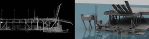
(3D Modelling of RoRo structures from laser scan point cloud data)
The Topographical Survey Of Historic Dry Docks
The third example listed above, a topographical survey of historic dry docks, was a particularly interesting project and one of the best for illustrating our range of topographical & bathymetric survey services. These historic dry docks first saw the construction of timber vessels, and the project was commissioned for heritage/archaeological purposes. We are always pleased to be able to assist with the preservation of heritage sites, so it’s no surprise that this project particularly excited our survey team.
Survey Work Undertaken For The Historic Dry Dock Project
As is often the case with heritage projects, we had to deploy several types of surveying practices to ensure the project reached a successful conclusion. One task we performed involved the survey of the underground culvert system, once used to drain one dock and fill another using steam powered pumps.
In addition, the client also required us to prepare colourised 3D laser scans, plots of plans and sections that showed every dock wall stone. This was essential for aiding the archaeologists to accurately record the methods originally used in its construction, as well as the sequence used and the materials it was built out of, allowing for proper documentation to occur before the site was re-developed for the modern era.
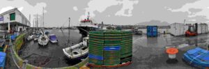
(Panoramic imagery is taken and used to colourise the point cloud data)
The Topographical Survey Methods Used In Our Coastal & Marine Projects
To properly assist our clients, a variety of the latest surveying methods are often required when we conduct surveys for the coastal & marine sector. The techniques we used in these recent projects includes:
– The Use Of Drones: Unmanned aerial vehicles (UAVs) are a great asset when aerial surveys are required. Drones allow surveyors to gather data from areas that would be difficult or dangerous for people to reach.
– Laser Scanning: This allows our topographical surveyors to measure and collect data from objects, surfaces and buildings in the form of point cloud data – which consists of millions of 3D coordinates to actually plot the site and surroundings.
– Photogrammetry: With photogrammetry our team is able to make precise measurements from photographs and other imaging sources and use this to determine distance between objects and locations.
– GNSS: The use of survey quality GPS to plot locations with pinpoint precision. This was particularly useful for examining any potential water ingress on harbour walls and investigating potential voids.
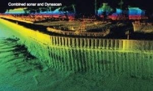
– Bathymetric Surveys: This allows us to map the details of underwater terrain and assess the depth of the water body. An essential step when refurbishing or constructing a coastal structure.
– Long Range Scanning From The Shore: To assess any damage to dolphin / mooring structures that needs to be repaired or replaced.
Topographical & Bathymetric Surveys For The Coastal And Marine Sector
If you have an upcoming coastal and marine project and require the assistance of expert topographical & bathymetric surveyors, Merrett Survey will be glad to help. To discuss your project and receive a free quotation, or to enquire further about our services, please contact us on 01397 362161 or by email at info@merrettsurvey.com.

Peter Merrett - Owner & CEO
Get in Touch


