

Aerial Surveys For Mining & Quarrying
As professionals in the surveying industry, we understand the pivotal role of aerial surveys for mining and quarrying. The utilisation of aerial technologies and methodologies has revolutionised how we approach data collection and analysis. By harnessing the power of UAV drones and LiDAR systems, we have unlocked a new level of precision and efficiency in surveying operations.
But what specific benefits do these aerial surveys offer, and how do they truly impact the bottom line of mining and quarrying ventures? Read on to find out more.
Benefits of Aerial Surveys For Mining & Quarrying
We know the significance of aerial surveys in mining and quarrying operations; they provide crucial insights into the terrain, helping us plan and execute projects efficiently. Understanding the benefits of aerial surveys is essential for optimising mining and quarrying processes. These advantages include:
- Enhanced accuracy: Advanced technologies like LiDAR and high-resolution cameras provide precise mapping and detailed insights into terrain and mineral deposits, leading to more accurate decision-making.
- Improved safety: Drones can inspect hard-to-reach or hazardous areas without putting human lives at risk, enhancing overall safety during survey operations.
- Cost-effectiveness: Utilising drones minimises costs associated with labour, equipment, and data collection, providing a more economical solution for mining operations.
- Scalability: Aerial survey techniques can be easily scaled to fit projects of various sizes, accommodating both small and large-scale operations.
- Integration with other technologies: Data from aerial surveys can be integrated with GIS and other analytical tools, enhancing overall resource management capabilities.
Plus many more. Our recent news article ‘Everything you need to know about drone surveys’ explains this survey type across different applications.
Understanding the importance of these survey types
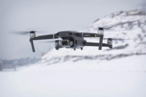
Utilising advanced aerial survey technologies in mining and quarrying operations significantly enhances efficiency and accuracy in data collection and analysis.
Aerial surveying for mining and quarrying plays a crucial role in optimising operations by providing detailed insights into the terrain, mineral deposits, and infrastructure. These surveys streamline the process of exploration, mapping, and resource estimation in mining projects, leading to more informed decision-making. By leveraging technologies like LiDAR and UAV drones, mining surveys can be conducted swiftly, covering vast areas with precision.
The data obtained from these surveys aids in designing mine access routes, monitoring slope stability, and calculating stockpile volumes accurately. Furthermore, aerial surveys support environmental assessments and infrastructure planning, ensuring sustainable and efficient mining practices.
Application of Drones in Mining Survey Operations
There are some key technologies driving aerial surveying in mining operations and these continually evolve to ensure precision and accurate data capture and analysis. By leveraging advanced drones and data collection methods, we can achieve detailed and reliable results for various mining projects across the UK and abroad.
Key technologies driving aerial surveying
It’s important to know what mining surveys are and how they are performed to assess the benefits of drones in this environment. Incorporating drones into mining survey operations significantly enhances data collection efficiency and accuracy.
Aerial drone surveying has revolutionised the mining industry by providing advanced survey technologies that improve planning, execution, and decision-making processes. By utilising drones equipped with GPS and LiDAR technology, mining companies can gather precise data rapidly, ensuring thorough mine surveys within set timeframes.
UAV Technology Advantages In Surveying
As we explore UAV technology advantages in surveying, safety enhancements through aerial surveying emerge as a crucial aspect. The ability to conduct surveys from a safe distance contributes significantly to risk reduction in mining operations. Additionally, environmental considerations in aerial surveys play a pivotal role in minimising ecological impact.
Safety enhancements through aerial surveying
Utilising UAV technology in aerial surveying enhances safety measures and operational efficiency in various mining projects. Mining aerial surveying with drones allows for close inspection of hazardous areas without risking human lives. What’s more, by providing accurate datasets with rapid turnaround times, UAVs increase the speed of surveying processes, reducing the time workers spend in potentially dangerous environments.
Drones are particularly beneficial for large-scale mining sites with extensive features to the survey, where traditional methods may be slower or riskier. This advancement marks a significant step towards ensuring the well-being of workers in the mining industry while maintaining high levels of productivity.
Environmental Considerations in Aerial Surveys
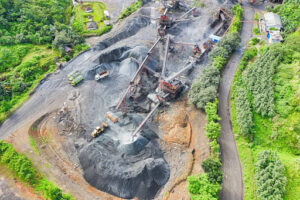
Our expertise in aerial surveys utilising UAV technology highlights the importance of environmental considerations in optimising surveying practices. When conducting aerial surveying for mining and quarrying, the use of aerial drone surveying techniques allows us to minimise our environmental footprint and gather data without disturbing the surrounding ecosystems or habitats. The ability to navigate challenging terrains and access remote locations through drones enables us to reduce the need for ground-based surveys that may disrupt natural environments.
The team at Merrett Survey has worked in mines and quarries across the world, with different countries always providing a different set of challenges in terms of terrain and ecosystems. However, with the advancement in technologies and working alongside site and project management, we are able to overcome any issues and maintain high standards across all types of surveys.
Moreover, aerial drone surveying aids in monitoring environmental changes over time, such as vegetation growth or water quality alterations, providing valuable insights for sustainable mining practices. By incorporating environmental considerations into our aerial surveys, we can ensure that our mining and quarrying activities are conducted responsibly, with minimal impact on the surrounding ecosystems.
Aerial Survey Data Acquisition and Analysis
Much of the data we collect via our aerial surveys can be leveraged to enhance decision-making processes, improve operational efficiency, and ultimately maximise the value of mining resources.
Maximising the Use of Aerial Data in Resource Management
In our experience, harnessing aerial data for resource management maximises efficiency and accuracy in surveying and analysis processes. This includes:
1. Enhanced decision-making: Utilising aerial mapping drones allows for real-time data collection, enabling quick and informed decisions in mining aerial surveying.
2. Optimised resource allocation: By leveraging aerial survey data, we can effectively allocate resources, reducing wastage and improving operational productivity.
3. Improved environmental impact assessment: Aerial data aids in conducting thorough environmental impact assessments, ensuring sustainable mining practices and compliance with regulations.
Speak To Our Expert Aerial Surveying Team For Mine & Survey Projects
Our highly skilled aerial surveying professionals are ready to assist you with tailored solutions for your mining and survey projects. With decades of experience and advanced drone technology at our disposal, we ensure precise data collection and insightful analysis.
Whether you need comprehensive site assessments, resource mapping, or safety inspections, our team is dedicated to delivering accurate, efficient, and cost-effective results. Contact us today to discuss how we can support your specific project requirements in more detail.

Peter Merrett - Owner & CEO
Get in Touch


