Merrett Survey were commissioned by a Plymouth based architect to provide a measured building survey of a block of partially occupied flats, to enable the design of a refurbishment scheme.
Whilst the output requirements were conventional, 2D plans, sections and elevations we utilised some alongside some new and innovative technology to achieve a very rapid completion in the field. We opted for this approach to minimise disruption to the occupants of the flats.
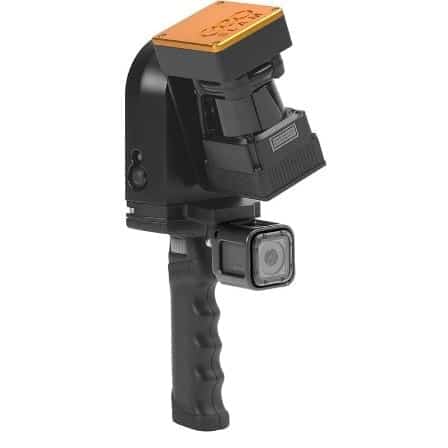
The image (bottom right) shows the Zeb-Revo laser scanner, which Merrett Survey used in Plymouth to survey the flats. The scanner incorporates an IMU (inertial measurement unit) and uses simultaneous localisation and mapping (SLAM) technology. This enables the scanner to compute its location, relative to its previous position, whilst surveying a site at walking speed. The equipment is handheld.
We used this mobile laser scanning technology to rapidly survey all the rooms and apartments in the building. This meant that we did not have to set up tripods inside properties and could be as non-intrusive as possible.
Survey control was placed outside the building using GPS and we then used a high accuracy, tripod mounted, terrestrial laser scanner to ‘traverse’ through the stair cases. The coordinated high accuracy data generated by the tripod scanner was used to transform the ‘point cloud’ data, created by the hand held Zeb-Revo to Ordnance Survey’s grid and height datum.
Such rapid data collection leads to cost-saving benefits, meaning these kind of measured building surveys can be competitively priced. On average, the accuracy achievable for internal building surveys is +/-15mm, which is suitable for producing most 1:50 floor plans.
When scanning occupied buildings such as nursing homes or hospitals, mobile scanning is perfect as we can generally collect detail for an entire room in 10-20 seconds, minimising disruption to residents. Where higher accuracy is required, we apply tripod mounted terrestrial laser scanning methods.
From the point cloud data, we can generate conventional 2D floor plans, elevations and sections in various CAD formats, but there is also the advantage of being able to create 3D fly-throughs and other 3D products, such as Revit BIM models.
If you would like to learn more about this rapid building survey project, please contact us. Look out for more related case studies landing across the Merrett Survey Limited website soon.