

What Are Mining Surveys & How Are They Performed?
As an established team of mining surveyors in the UK, who have worked on mine sites all over the world, we understand how valuable they can be to the success and profit of a mining operation, above or below ground. Learn here how these services are conducted using modern surveying technology, and most importantly, what benefits they can offer to a mining operation. In this article, we share everything we’ve learned on the topic over our 40 years of conducting mining surveys.
What Are Mining Surveys?
In essence, mining surveyors accurately measure existing or planned mine workings to assist with their design, the planning of the operation, and to determine and improve the safety of any surface and underground mining operations. All of these aspects are of the utmost importance if the project is to be carried to a successful conclusion. With the right equipment, an experienced mining surveyor can map out the surface and underground areas of the mine site and identify hazards that could pose a risk to personnel.
All in all, a quality mining survey can make all the difference to improving the safety, efficiency and productivity of a mining operation, and so it is always worth contacting a professional.
What Information Is Gathered In A Mining Survey?
While the exact information gathered as part of a mining survey will vary with the project’s aims and the mine site itself, this information is the most likely to be gathered for most operations:
- For mining prospects we map the terrain to allow detailed planning
- Using a 3D map to merge geological and geophysical data gives greater understanding of the existing and potential ore bodies/reserves
- Comparing existing surface to planned mining operations to plan and cost overburden stripping work
- Mapping the surrounding area and access routes – for detailed planning of rail and road links
- Determine the location of pre-existing tunnels, mines and other infrastructure
- Information on underground working to help develop key infrastructure such as ventilation systems or structural elements
- Full survey and 3D modelling is a vital part of due diligence for a new mining investment, to fully record all existing assets and infrastructure
- Plan water supplies, tailing dams, process plant site, drainage and all environmental factors
- Stockpile and waste tip volumes
This list is far from exhaustive, but on the whole this is the information that an operator of a mining project will be most interested in.

What Technologies Are Used In Mining Surveying?
In the modern day, the mine surveying industry has a number of key technologies to assist with gathering information. These not only allow for more accurate data, but greatly improve the speed and safety of collecting it as well. These are the key technologies our mining surveyors can apply to your projects:
Laser Scanning
Laser scanning from the ground or from the air allows for the capture of a huge level of detail over the chosen area/surface which can then be presented in a 2D or 3D format to display the work area in great detail. The scanners produce a light wave / laser fired at a rate of a million times per second, which reflects off of surfaces and back to its sensor. The time taken for the light wave to return allows it to calculate the distance to a surface, and knowing the direction and vertical angle of the laser beam allows for the computation of 3D coordinates of all surfaces surveyed.
Surveying with laser scanning is much faster and safer than gathering this data with traditional methods, which is invaluable for mine sites where the terrain is often cramped, hazardous and difficult to traverse.
Mobile Mapping
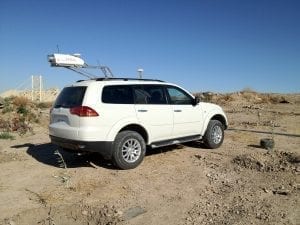
Mobile mapping increases the speed of laser scanning surveys even further. In mobile mapping, laser scanning equipment is mounted on a vehicle for the rapid gathering of data on quarries, opencast mine sites, and any other above-ground infrastructure. It can even be driven underground.
Despite the rapidity of the process, all data gathered is still of survey-grade quality, and thus can be used for a wide range of applications. Not only does this technique reduce the time required to survey the mine site, but also improves the safety as features can largely be captured at a distance and survey staff primarily remain in the vehicle away from rock faces or moving machinery.
UAVs & Drones
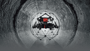
UAV (Drone) surveying has seen a great rise in its application to mining surveying over the past decade. Lightweight drones allow for the rapid mapping of opencast mine pits or quarries without the need for the surveyor themself to directly venture on-site at all.
Cameras are mounted onto these drones which can take hundreds of overlapping photos as the device flies over the mine site. These images are then converted into a detailed digital terrain model to be used throughout the project.
Merrett Survey recently surveyed 25 square kilometres in Greenland, well above the Arctic Circle. This was a mining prospect site. Often larger areas are surveyed using a full sized aircraft (see below) and we have also completed work using this method. For small to medium size sites, UAV work is ideal as we can take advantage of suitable weather windows more rapidly than you can with the full size aircraft.
Laser scanners can also be carried for lidar survey work.
Note: UAV is an ‘unmanned aerial vehicle’, but is often referred to as a drone.
LiDAR & Aerial Mapping
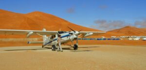
Lidar, or “light detection and ranging”, is an immensely powerful tool for mining surveyors. This involves attaching laser scanning devices to manned or unmanned aircraft to measure distances & features on the ground. Up to 500,000 laser points are emitted per second to map the terrain with great speed, and the inertial measurement unit ( IMU ) accounts for the aircraft’s roll, pitch and yaw in the data to ensure a high level of accuracy.
Lidar on a full size ‘manned’ aircraft (fixed wing or helicopter) can be equipped with cameras as well, so that laser scanning and aerial imagery /photogrammetric survey, can be conducted at the same time. This setup enables the rapid coverage of much larger areas than can be covered by a UAV / drone.
OLYMPUS DIGITAL CAMERA
Remote Sensing
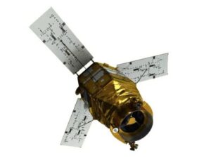
Mapping using satellite imagery is a technique growing in popularity in the mine surveying sector, because the cost is coming down and the image resolution is getting better all the time. This performs a similar function to aerial & drone mapping, but uses a satellite rather than an aircraft to obtain the imagery. In particular, mini-sats (constellations of multiple remote sensing satellites), are comparatively low in cost and enable full coverage of the earth’s surface with rapid repeat surveys. With these and more new developments on the way, remote sensing may replace fixed-wing aircraft surveys entirely in the coming years.
What Are The Benefits Of Mine Surveys
While we’ve explained, in broad terms, what the purpose of mine surveys are, it is important to understand what specific benefits they can offer to an operation, and therefore why you should contact an experienced team of mining surveyors like those at Merrett Mining Surveys for your next project. The key benefits a mine survey can offer are:
- 1)Prevent Cave-ins: The accurate study of underground areas and assistance with the development of support infrastructure can help prevent cave-ins and subsidence and reduce injury or fatality if one should occur.
- 2)Limit Environmental Pollution: Mining surveyors can provide key information about the environmental impacts of the extraction operation and can help limit damage to the surrounding area.
- 3)Help Local Authorities: This information on environmental pollution can also be of great significance to local governments and other authorities, and so having an accurate measurement of this can help ensure the operation is compliant with regulations.
- 4)Assistance With Excavation Design: The detailed mapping provided in a mining survey can be invaluable for the planning and construction of tunnels, mines, and other excavations.
- 5)Assistance With Above-Ground Infrastructure: Not only will a mining survey be of great importance for planning excavations, but can also provide information on where it is safe to build necessary infrastructure at the site, plus planning access routes in / out of the site.
- 6)Improve Profitability: Gaining an understanding of what quantities of ores and minerals are present in the worksite, as well as what will be required to extract them, is invaluable for increasing the profitability of the operation.
- 7)Accurate Mineral Rights Boundaries: In any mining project ensuring your boundary is placed correctly is of utmost importance, and making a mistake could result in losses of millions of dollars in minerals beneath the ground. Cadastral/Boundary surveys with Mining Surveys can ensure that your boundaries are set correctly.
Expert Mining Surveys With Our Team
At Merrett Mining Survey, we have experience conducting surveys in 62 countries, on every Continent and for all types of mining projects. If you have a mining operation that you think could benefit from a mining survey, then don’t hesitate to reach out, we’re certain to have experience with whatever you are planning.
Contact us on 01392 362161 or at info@merrettsurvey.com and speak to one of our expert mining surveyors for a free, no-obligation quote. We look forward to working with you soon.
Who Carries Out Your Mining Survey?
Merrett Survey is an experienced team of mining and quarrying surveyors working across the UK and internationally. To discuss your project or request a quotation, get in touch with our team.

Peter Merrett - Owner & CEO
Get in Touch


