
topographical survey highway junctions

Road Surveys

Merrett Survey Limited has worked across all types of road survey, for new build, improvements, widening schemes and maintenance, in all regions of the UK and around the World. This has included all grades of road from motorways, dual carriageways, bypasses, urban, rural and gravel roads across Africa. We have even surveyed a road made of coral in the Philippines!

Road Survey Projects Have Included:

  • Site surveys for ‘intelligent motorway’ signage.
  • Bypasses.
  • New and re-designed roundabouts and junctions.
  • Bridge clearances undertaken by laser scanning.
  • Bridge condition surveys using laser scanning and 3D BIM modelling.
  • Structure monitoring.
  • Bridge joint replacement surveys.
  • Road surfaces – high precision levelling work – volumes of overlay.
  • Primary and secondary geodetic control networks.
  • Drainage asset surveys – manholes, drain CCTV inspection.
  • Utilities services – UUD (underground utility detection) / GPR (ground penetrating radar).
  • Road clearance surveys – for the passage of abnormal loads such as wind turbines / blades.
  • Cadastral survey for land ownership and compulsory purchase.
  • Noise studies.
  • Mobile mapping – vehicle based laser scanning – for highway topographical survey.
  • Cycle lanes – cycle tracks.
  • Dedicated bus lanes – some of this work was undertaken for Transport for London prior to the 2012 Olympics.


Speak to Us About A Road Survey

Wish to speak to our topographical surveys team about a highways survey? Please contact us by filling out a form below, by email or by phone – our team are happy to discuss how a road survey could benefit the project at hand.
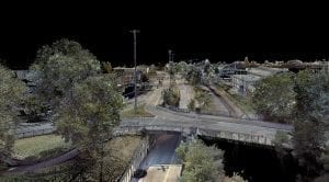
Colourised 3D laser scan data

3D laser scan survey – Bristol for new bus lanes


Asset survey for UK Highways Agency

Asset inventory data collection for Highways England

Find Your Bespoke Road Survey Solution Today

Contact Our Specialists

Contact
Contact Us